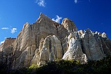
Omarama Clay Cliffs
Appearance

The Omarama Clay Cliffs, also known as the Ahuriri River Clay Cliffs and the Clay Cliffs Paritea are a group of cliffs in southern New Zealand.[1] They are located close to the north bank of the Ahuriri River, some 10 km to the west of the township of Omarama.
The cliffs serve as a tourist attraction in the area and they are privately owned.[2] There is a fee to park.
Formation
[edit]The cliffs are made up of layers of silt and gravel that were formed during glacial erosion[3] around two million years ago, and are part of the Hawkdun Group of sediments. The cliffs were uplifted by the nearby Ostler Fault.[4]
44°29′20″S 169°52′00″E / 44.48889°S 169.86667°E
References
[edit]- ^ "World famous in New Zealand: The Clay Cliffs, Omarama". Stuff. Retrieved 1 April 2019.
- ^ "Omarama Clay Cliffs | Waitaki, New Zealand". www.newzealand.com. Retrieved 1 April 2019.
- ^ "Clay Cliffs Paritea | Omarama, New Zealand Attractions". www.lonelyplanet.com. Retrieved 1 April 2019.
- ^ Geocaching. "Geocaching - The Official Global GPS Cache Hunt Site". www.geocaching.com. Retrieved 1 April 2019.
